Report ID: 1357 |
Published Date: 10 Sep 2026 |
Report Format: |
Delivery Timeline: 48-72 Business Hours
Infrared Thermal Imaging Drones Market Outlook:
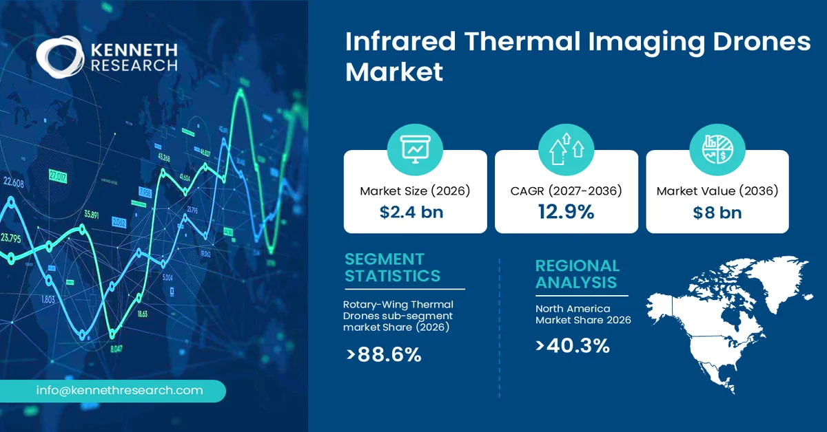
Infrared Thermal Imaging Drones Market size was valued at USD 2.4 billion in 2026 and is projected to reach USD 8 billion by the end of 2036, rising at a CAGR of 12.9% during the forecast period, i.e., 2027–2036. In 2027, the industry size of the infrared thermal imaging drones market is estimated at USD 2.7 billion.
The primary growth driver for the infrared thermal imaging drones market is the increasing use of unmanned aerial systems for remote inspection, emergency response, infrastructure monitoring, and thermal anomaly detection.
The infrared thermal imaging drones market comprises unmanned aerial vehicles equipped with infrared or thermal cameras that detect and visualize variations in surface temperature. These systems combine an aerial platform, thermal imaging payload, navigation and flight-control technologies, data-processing capabilities, and, increasingly, analytics or AI software.
Key characteristics include rapid aerial deployment, non-contact inspection, operation in low-light or nighttime environments, georeferenced thermal imagery, and integration with RGB cameras, LiDAR, mapping software, and automated analytics. Rotary-wing platforms are particularly suited to close-range inspection because they can hover and maneuver around complex assets.
Key Infrared Thermal Imaging Drones Market Insights Summary:
Key Takeaways: Market Trends & Insights
- Infrared Thermal Imaging Drones Market is projected to grow from USD 2.4 billion in 2026 to USD 8 billion by 2036 at a 12.9% CAGR
- North America accounted for the largest regional share at 40.3% in 2026, supported by advanced drone infrastructure, strong enterprise adoption, and increasing deployment across infrastructure inspection, public safety, and industrial applications
- Rotary-wing thermal drones remained the leading Product Type segment with an 88.6% market share in 2026, supported by superior hovering capability, maneuverability, and suitability for close-range inspection of difficult-to-access assets
- High-resolution sensors are expected to witness strong growth as industrial users increasingly require detailed thermal imagery, multisensor integration, and improved anomaly detection for infrastructure and asset inspection
Market Drivers
- Expansion of remote and hazardous-asset inspection
- Integration of thermal imaging with advanced drone analytics
- Increasing deployment for emergency response and wildfire monitoring
- Adoption of multisensor drones for predictive and condition-based maintenance
Challenges
- Regulatory and operational restrictions
- Thermal-data quality, interpretation, and system-integration complexity
Infrared Thermal Imaging Drones Market Overview & Supply Chain
Global adoption is increasing as enterprises and public agencies seek safer inspection methods, faster field data acquisition, and greater visibility into assets that are difficult or hazardous to access. Thermal imaging expands drone utility beyond conventional visual surveying by allowing operators to identify heat anomalies and other conditions that are difficult to observe with standard cameras. The U.S. Federal Aviation Administration has specifically found that UAS equipped with thermal and visual cameras can benefit airport personnel inspecting hard-to-reach or inaccessible areas and detecting people or vehicles.
The industry value chain begins with suppliers of semiconductors, infrared detector materials, optical components, lenses, batteries, motors, flight-control electronics, communication modules, and structural materials. Sensor and camera manufacturers integrate infrared detectors, optics, calibration systems, and imaging electronics into compact payloads. Drone manufacturers then combine these payloads with airframes, propulsion systems, navigation hardware, onboard computing, and software. System integrators may add RGB cameras, LiDAR, mapping tools, AI analytics, and cloud-based platforms.
Infrared Thermal Imaging Drones Market: Growth Drivers & Challenges
Growth Drivers
- Expansion of remote and hazardous-asset inspection: The growing use of drones for inspection is accelerating demand for thermal imaging payloads because infrared sensing enables operators to evaluate assets without placing personnel directly in hazardous or difficult-to-access environments. Thermal-equipped drones can support inspections of electrical equipment, industrial facilities, infrastructure, emergency scenes, roofs, pipelines, and other assets where temperature anomalies provide an indication of potential problems.
- Integration of thermal imaging with advanced drone analytics: A second growth driver is the convergence of thermal sensing with AI, mapping, computer vision, and multisensor data processing. Instead of treating thermal imagery as a standalone visual output, industrial users increasingly expect drone systems to convert imagery into actionable information, such as identifying abnormal heat patterns, prioritizing inspection points, comparing conditions over time, and supporting maintenance decisions.
Challenges
- Regulatory and operational restrictions: Drone operations remain subject to airspace authorization, pilot qualification, operating restrictions, and requirements that vary by jurisdiction and application. These constraints can complicate deployment around airports, populated areas, critical infrastructure, and controlled airspace. Beyond regulatory compliance, organizations must establish operating procedures for weather, communications, flight safety, data security, and thermal-image interpretation.
- Thermal data quality and system integration: Thermal imaging performance depends on sensor characteristics, atmospheric conditions, distance from the target, emissivity, calibration, environmental conditions, and operator expertise. A thermal image can reveal an anomaly without necessarily identifying its precise cause, creating a requirement for qualified interpretation and complementary inspection methods. Integration with existing enterprise asset-management and inspection systems can also be challenging when organizations operate heterogeneous drone platforms and data formats.
Infrared Thermal Imaging Drones Market Size and Forecast:
| Report Attribute | Details |
|---|---|
| Base Year |
2026 |
| Forecast Period |
2027-2036 |
| CAGR |
12.9% |
| Base Year Market Size (2026) |
USD 2.4 billion |
| Forecast Year Market Size (2036) |
USD 8 billion |
| Regional Scope |
|
Infrared Thermal Imaging Drones Market Segmentation Analysis:
Product Type Segment Analysis
In the Product Type segment, the Rotary-Wing Thermal Drones sub-segment is anticipated to capture the largest market share of 88.6% in 2026.
Unlike fixed-wing platforms, rotary-wing systems can remain stationary near a target, adjust position precisely, and capture repeated thermal observations of towers, substations, buildings, industrial equipment, bridges, and other vertical or confined assets. Their maneuverability also supports emergency-response operations where the inspection target can change rapidly.
The U.S. FAA's airport-perimeter research provides direct evidence of the technical requirements supporting this segment. Its evaluation found that thermal and visual cameras provide benefits for inspecting inaccessible areas, while establishing a minimum recorded thermal-camera resolution of 640 × 512 pixels for the tested application.
Resolution Type Segment Analysis
High-resolution sensors are projected to gain importance as thermal drone users demand more detailed imagery for asset inspection, anomaly characterization, and automated analysis. Higher spatial detail enables operators to distinguish smaller thermal patterns and correlate them more effectively with visible structural features. This is particularly relevant when drones operate close to electrical equipment, industrial machinery, bridges, buildings, and other assets where inspection decisions depend on localized anomalies. The combination of thermal sensing with other high-detail datasets increases the usefulness of each flight and supports automated interpretation. Suppliers are consequently expected to focus on sensor miniaturization, optical performance, stabilization, radiometric accuracy, and software compatibility.
Our in-depth analysis of the global infrared thermal imaging drones market includes the following segments:
|
Segment |
Sub-segment |
|
Product Type |
|
|
Resolution of Thermal Sensor |
|
|
Application |
|
|
Agriculture |
|
|
Utilities & Energy |
|
|
Public Safety & Security |
|
|
Industrial Inspection |
|
Infrared Thermal Imaging Drones Market Regional Insights:
North America Market Trends & Insights:
North America holds the dominant regional position, accounting for 40.3% in 2026, supported by established drone infrastructure, strong enterprise adoption, advanced aerospace and sensor capabilities, and demand from utilities, energy companies, infrastructure operators, public-safety organizations, and industrial users. The region benefits from an increasingly structured regulatory environment and substantial investment in commercial UAS capabilities.
In the U.S., adoption is supported by federal research, established certification pathways, and expanding use of drones for infrastructure inspection, emergency response, energy assets, and public safety. Federal agencies are also actively testing UAS technologies, creating demonstration environments that can accelerate commercial deployment.
Canada represents an important complementary market, particularly for infrastructure inspection across its geographically dispersed assets. Government-supported innovation programs have backed drone solutions combining thermal imaging with other sensors and AI for infrastructure assessment.
Asia-Pacific Market Trends & Insights:
Asia-Pacific presents substantial long-term demand potential as industrial modernization, infrastructure development, energy investment, disaster management, and precision monitoring increase the need for aerial inspection technologies. Japan and China are particularly important markets because of their advanced manufacturing capabilities, large industrial bases, infrastructure requirements, and growing interest in automated inspection.
Japan is positioned toward high-value applications emphasizing reliability, precision, robotics integration, and infrastructure maintenance. Demand is likely to favor sophisticated thermal platforms capable of integrating with established industrial inspection processes.
China offers opportunities across industrial inspection, energy infrastructure, emergency response, agriculture, and public-sector applications. Its extensive electronics and drone manufacturing base can facilitate rapid product development and integration of thermal payloads, AI analytics, and autonomous flight capabilities.
Leading Companies Operating in the Global Infrared Thermal Imaging Drones Market:
Here is a list of upstream, downstream, and key players operating in the global infrared thermal imaging drones market competitive ecosystem:
- DJI (China)
- Company Overview
- Business Strategy
- Key Product Offerings
- Financial Performance
- Key Performance Indicators
- Risk Analysis
- Recent Development
- Regional Presence
- SWOT Analysis
- Skydio (U.S)
- Autel Robotics (China)
Recent Developments
- January 2025: On January 8, 2025, DJI introduced the Matrice 4 Series, comprising the Matrice 4T and Matrice 4E. DJI stated that the new enterprise drones incorporate smart detection, AI computing, enhanced sensing, and laser-rangefinder capabilities.
- February 2025: On May 5, 2025, Skydio announced delivery of the first systems under the U.S. Army's Short Range Reconnaissance Tranche 2 program. The company stated that the delivered X10D systems include a Teledyne FLIR Boson+ thermal sensor and are designed for intelligence, surveillance, and reconnaissance missions.
Frequently Asked Question
In 2026, the infrared thermal imaging drones market exceeded USD 2.4 billion.
The infrared thermal imaging drones market is projected to reach USD 8 billion by the end of 2036, expanding at a CAGR of 12.9% over the forecast period (2027-2036).
The major players in the market are DJI, Skydio, Autel Robotics, Parrot, Teledyne FLIR, and others.
In the Product Type segment, the rotary-wing thermal drones sub-segment is anticipated to capture the largest market share of 88.6% in the future and exhibit lucrative growth opportunities during 2027-2036.
North America is projected to hold the largest market share of 40.3% by the end of 2036 and provide more business opportunities in the future.
Why Choose Kenneth Research ?
-
Insight with Impact : We don’t just gather data — we uncover stories, trends, and opportunities that fuel business growth.
-
Experts Who Get It : Our team speaks your industry’s language and knows what really matters to your customers and market.
-
Custom-Built for You : Forget one-size-fits-all. We craft research and consulting solutions as unique as your business vision.
-
Partners, Not Just Providers : We work with you, not for you — collaborating closely to turn insights into smart, strategic moves.
-
Results That Speak : Our work powers brands, startups, and industry leaders alike — with a track record of ideas that work in the real world.
Report ID: 1357 |
Published Date: 10 Sep 2026 |
Report Format: |
Delivery Timeline: 48-72 Business Hours
Copyright © 2025 Kenneth Research. All rights reserved. Terms of Use | Privacy Policy
